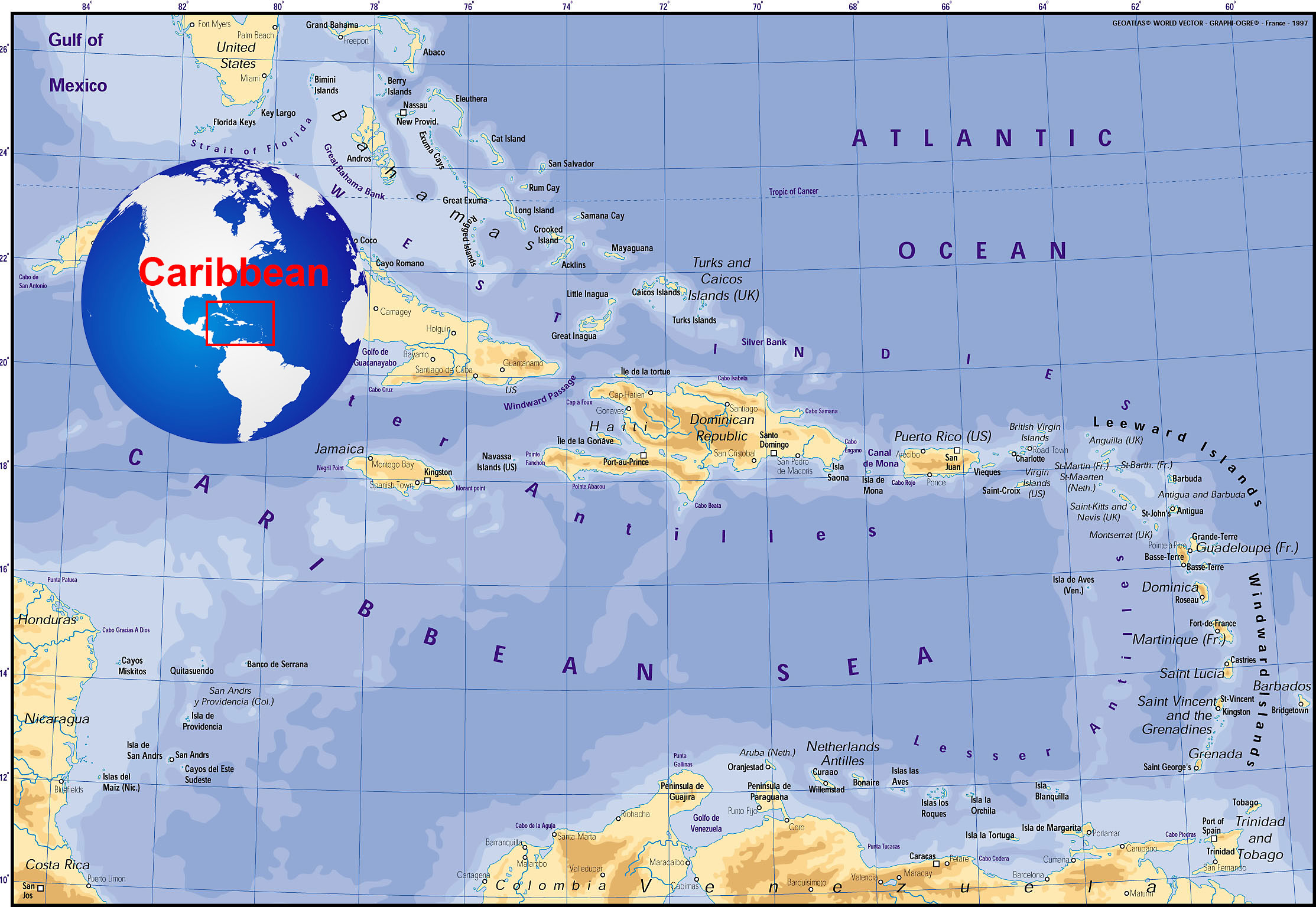
Sailing the Caribbean
It seems to be always blowing 20 knots from the Atlantic either from the North east or South East direction (the wagging of the dogs tail), and the seas are normally 4-6 ft on the windward side of the islands, so we always sail on the leaward side of the islands to get the calmer seas and hopefully calmer winds, which works except when you are between the islands where you get the full strength of the Atlantic coming through. Sailing from island to island is usually a day sail – early morning to just before dusk as a maximum (12 hours). It can be longer sail, as in Trinidad to Grenada. A noon start from Trinidad and an over night sail arriving in Prickly Bay, Grenada for around 9 am. This way you are sailing in deep water during the night and arrive in the morning in plenty of light to negotiate the reefs at the entrance to Secret Harbour.
There are two seasons – rainy season and dry season, and as the seasons progress and it becomes rainy season otherwise known as Hurricane season (July to November) and if you are North in the Leaward Islands, your best bet is to start sailing South to the Windward Islands. There is no rush if you keep an ear out on the weather reports. As you can make the most southern Island – Trinidad, off the coast of Venezuela in 3 days. Most sailboats have already started to migrate southward around this time of year and as a result the anchorages can be a little crowded. Some stay in St. Lucia as this is the most northerly island that the insurance companies will insure your boat for Hurricane damage. Some boats stay in picturesque Bequia, and the South shore of Grenada in Prickly Bay, Secret Harbour, or Hog Island. When we were cruising the area there was no marinas other than these first two mentioned. But I understand that the marina industry has flourished on Grenada’s South Shore, with many marinas opening up. We liked to go even further south to Trinidad and have made many friends there.
In Trinidad we never liked the Hustle and bustle of the “Power Boats” marina, the anchoring was difficult, crowded and deep (nowadays it there are loads of slips to be had). We preferred to anchor off Trinidad and Tobago Yachting Association (TTYA) in Hearts Cut Bay, Chaguaramas. Since we first arrived in 1992 there was plenty of space outside the moored sailboats. I think there was 2 of us anchored at the time. In the 4 years we were in the area the marina industry exploded. There were at least 6 more marinas and a major development – Cruise Inn, that opened up. As well as many supply businesses. If you want something repaired or need materials to do repairs, this is the place to get it done.
My favorite “Hurrican Holes” are starting with (keep in mind the further down the list and down island, you go the better the odds that the Hurricane will vear to the north as it comes across the Atlantic) –
Antigua – English Harbour on the south coast (as any islands North of this is just asking for it – see Hurricanes below).
Guadaloupe – Riviere Salee (if you are caught out and have some time) as you can enter from the North or the South to the center of the butterfly island (will be crowded).
Martinique – Le Marin in the south of the island. Plenty of little bays surrounded by mangroves (will be crowded – see the video on the Sailing The Caribbean – North to Martinique).
St. Lucia – The (small inner) Rodney Bay Lagoon, only space for a few boats. The outer large Rodney Bay is too open from the West.
Carriacou – Tyrrel Bay on the south west coast – can be a little shallow in the mangroves. The large bay can accomodate many yachts, but is open to the West.
Grenada – Mt. Hartman Bay Tucked far in there are mangroves all around (will be crowded). As the Moorings have many yachts that they put in the mangroves when there is the danger of a Hurricane. There is I hear good “Holes” to the East with Port Egmont and Calivigny Harbour But have never tried these locations.
Trinidad – Heart’s Cut My favorite – adjacent to TTYA, as the Hurricanes – almost – never come this far South. The only thing better is to haul out and dig a trench the size of your keel, slope and pad the sides and put your boat into it.
Venezuela – Mochima – just looking at it on a chart, you can see dozens of hiding “Holes” and it goes 3.5 nm inland.
Venezuela – Chichiriviche Bay Due South from Bonaire on the Venezuelan Coast. We have weathered a major storm tucked away in in the back here. As we had plenty of notice while staying in Bonaire (not a place I’d like to be in a storm). The wind reversals throw all the boats onto the shore, and that is in normal weather!
Not much around in Chichiriviche Bay except on the weekends when the locals from the nearby town of Chichiriviche (fun to say when learning Spanish) come to the beaches to play. Weekdays there are just the local fishermen. When we were the single boat in the bay (read – target). We kept going up and down from below while alternating clothes and no hat/hat while doing chores on the deck – to make it look like there were 4 of us onboard instead of 2. Makes it less likely to be robbed. Not sure how effective it was. All I can say we were there for 3 days and were never robbed. The fishermen probably thought we were mad and best to leave alone! Better to speak to your fellow cruisers and arrive with a few boats for greater protection.
After a few seasons of cruising up and down the islands, you begin to recognise many boats, and it is very easy to make sailing friends, and there is nothing better than dropping your anchor in a foreign bay only to see a few familiar boats already there. It was like a floating community that sailed up and down the islands each year, usually all ending up in Trinidad for Carnival time!
Favourite places to short stop (in good weather)
Roadtown – British Virgin Islands
Antigua – English Harbour
Isle Des Saints – Guadeloupe
Rodney Bay – St. Lucia
Tobago Cays – St. Vincent and the Grenadines
Favourite places to chill out (long term)
Marsh Harbour, Great Abaco, Bahamas (“chicken” harbour)
Boqueron, Puerto Rico
Port Elizabeth – Bequia, St. Vincent and the Grenadines
Tyrell Bay – Carriacou – St. Vincent and the Grenadines
Mt. Hartman Bay – Grenada
Hart’s Cut – Chaguaramas – Trinidad Stayed a total of 4 years (and survived 9 Carnivals!)
Margarita Island – Venezuela (Not recommended because of the current economic turmoil)
Puerto La Cruz – Venezuela (Not recommended because of the current economic turmoil)
Islas Las Aves – Venezuela (Not recommended because of the current economic turmoil)
Klein Bonaire – Bonaire
Weather
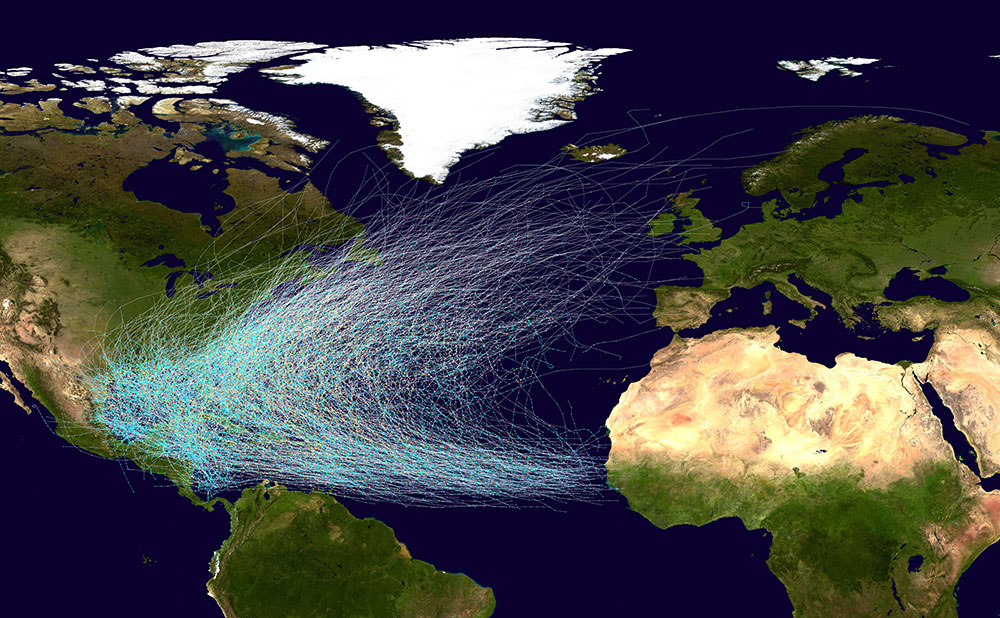
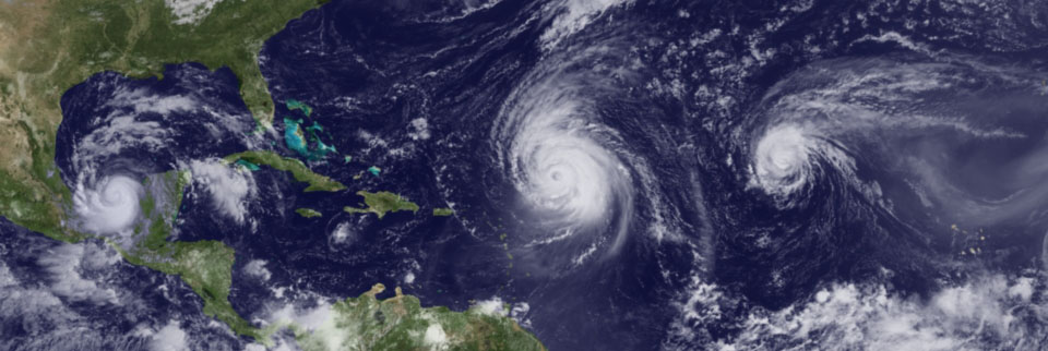
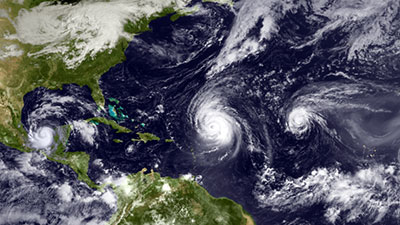
Every 2 to 3 days there is a “Tropical Wave” that originates from the West Coast of Africa as a low, and travels Westward across the Atlantic to the Caribbean. If it does not rotate while heading across you get the typical squally weather in the islands, if the wave starts to rotate slowly on its journey across the Atlantic it becomes a “Tropical Depression”. If it continues to rotate at a faster pace and tightens you get a “Tropical Storm”. If the tightening and rotation increase (usually due to warm water conditions feeding the storm more energy) you get a Hurricane. The Hurricane season is usually from June to November, and most sailboats head to the lower Caribbean Islands – The Windwards of the Lesser Antilles, to avoid the Hurricanes. Anywhere from St. Lucia and down to Trinidad and Tobago, as a typical Hurricane will come across and veer to the North along it’s Westward path. There are of course exceptions, and if you look at the image of all historically recorded Hurricanes in the Caribbean, there is not any island that has not been affected at some time. So sailing the islands between the tropical waves becomes the norm.
Weather Information (Reception)
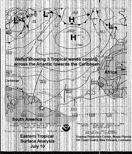
At the time (1990s) getting accurate weather information was not as easy as it is now. With every developed bay and marina offering Wifi, your now have an unlimited number of sources to receive accurate weather information in real time over the Internet. But back then all the information came over the radio in the HF bands: There was Voice from the NMN, Chesapeake, or NMN, Chesapeake or WWV Time Tick with Storm warnings at 8 min after the hour, that was quick and precise. It was handy to have a tape recorder near by to tape this and you could actually draw a crude weather map from the computerised voice information. As well as radio Teletype (RTTY), and Morse Code versions from the same source. But best of all was Wefax, and Satellite Imagery, Wave Heights … using a demodulator (that we built and sold) that went between the HF radio (Ham or Marine SSB) and a laptop. Using free software on the laptop that would translate Radio Teletype, and Morse code and Wefax into something that could be understood – usually a short version of the weather in English or Wefax (Weather Faximile) – receiving monochrome analogue picture information through a standard voice audio channel. This would give you a fairly accurate weather chart of the Caribbean, in which the tropical waves were all marked. The above image is one that we actually received and was typical of Wefax reception. Despite all the radio reception interference that resulted in all the vertical lines that makes the image hard to see. This Tropical Surface Analysis showing the tropical waves approaching the Caribbean – was like gold dust. It would make it far easier in working out a good departure day for sailing between the islands. Usually just after a tropical wave passes through. They transmitted a number of “Products” and transmitted round the clock. After a number of years sailing the Caribbean, I accumulated variety of sources for weather reception on the HF bands. In fact I wrote an article on this subject that was published in the Caribbean Compass that was available in most of the islands. And was surprised to still see my list of sources published and credited many years after I had left the area. Just checked the Caribbean Compass, and I’m now listed as “Other Cruisers” Well I guess it has been 20 years. I see they have dropped all the Morse, RTTY and Wefax Frequencies. I guess these charts are all readily available from the Internet nowadays, as they quote a few websites. But hey, it is in the exact format that I had in my original article! – see Caribbean Compass – Selected Shortwave Weather Reports.
.
Internet
More information is readily available on the Internet from a Google search for HFFax or Wefax.
http://www.hffax.de/
Weather
With a connection to the Internet via WiFi in most anchorages, cruisers can now view live feeds like the following from NOAA – GOES East – Satellite
Tropical Surface Analysis , Hurricane Tracking, 24 hr Winds, Caribbean satellite from –
or their Interactive Weather Map
Live Shipping Feed
With the internet you can even get live shipping feeds for the whole world from Ship Finder https://shipfinder.co
Zoom in or out using the controls at the top left. The numbers ar the actual ships being tracked and is a live feed. Click on any vessel to see more data including tracking information – name, type, status, speed, direction, destination, e.t.a., location (lat & lon), size, draft, call sign, the flag the vessel sails under, and even some images of the vessel.
Weather and Shipping Data availability for even the small sailboat cruiser has improved tremendously over the years!
Communications
Likewise before the arrival of the Internet, communications was a bit of a challenge. We were fortunate to have studied for and passed our Amateur radio license and been grandfathered to advance status before leaving Canada. Our call sign was VE0MMG Which meant that we were without any (Canadian) Province (VE0) Maritime Mobile (MM) and the 7th license to have such a call sign (G). We were able to call the Mississauga Maritime Mobile Net on 14,121 Mhz, located in – what else – Mississauga, Ontario, every morning to let them know of our position and progress … We always enjoyed having a chat with fellow Canadians, and really enjoyed placing a phone call to my mum in Toronto every day for a few minutes. Even although she was in her late 70’s she was getting quite used to speaking and then saying “over” to let Ernie throw the transmit / receive switch in Mississauga. We certainly miss chatting with Doug (VE3NBL), Ernie (VE3EGM) and Ron (VE3AUM) every day while under way and in remote anchorages. And it was great to have contact with “civilisation” in some of the remote islands, where there were literally no one around, and we were on our own.
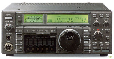
The Icom IC-735 radio was also a general coverage radio, and we could pick up the news from BBC, Radio Canada, and VOA and find out what was happening with the rest of the world. As well as using the Marine bands to keep in contact with other sailors that we had met over the years, no matter what the distance. All you have to figure out is the distance between location A and Location B, the time of day/night all relating to the Sunspot number – and this is easy with a little Propagation Prediction program in the laptop like – DXprop or HamCAP. We used local Marine VHF frequencies if we were within 15 miles or so.
Hurricanes
If you do find that you are caught out in an anchorage as a storm or Hurricane weather approaches there are a few things you can do to improve your situation. There are a few “Hurricane Holes” where you can tuck a sailboat away. They are usually ringed with mangrove trees that are virtually impossible to pull out as they have very extensive root systems and make perfect mooring ties. The idea is to drop a couple of anchors off the stern or bow – depending on which way you want to lie (stern in or bow in), and run a couple of lines to the mangrove trees, and just tighten everything up. Strip everything off the deck and you are good to go.
Hurricanes rotate counterclockwise in the Northern Hemisphere. So with a Hurricane moving in a Westerly direction, the highest winds will be in the bottom half of the Hurricane. Rotational speed PLUS directional speed across the Atlantic. Say, 80 knots plus 15 knots equals 95 knots in the bottom half. Likewise the least winds will be in the top half of the hurricane. Rotational speed LESS directional speed. Which would be 65 knots.
If the Hurricane passes to the north of your position. You will experience the strong wind coming first from Southerly direction, even stronger winds from a Westerly direction and “easing” to a Northerly direction. So the best place to tie to the mangrove trees is the East side of a bay. This way you will not only have the mangrove trees holding you in the strongest winds, but the winds will be “offshore” away from the shore, rather than “onshore” towards the shore.
The opposite is true if the Hurricane passes to the South of your position. You will experience strong wind coming first from Southerly direction, stronger winds from an Easterly direction and “easing” to a Northerly direction. So the best place to tie to the mangrove trees is the West side of a bay. This way you will not only have the mangrove trees holding you in the strongest winds, but the winds again will be “offshore” away from the shore, rather than “onshore” towards the shore.
This does not take into account any storm surges generated from a Hurricane which can be substansial if the anchorage is exposed to the open sea..
The truth is that if a major Hurricane goes directly over your position there is no such thing as a “Hurricane Hole”.
In our experience of keeping track of Hurricanes in the years that we were cruising, there was none worse than cat4 Hurricane Luis when it hit St.Martin in 1995. There were 4 Hurricanes in the Atlantic basin at the same time that season. Luis was the 6th Hurricane of a total of 12. St. Martin – the Dutch / French island in the Leeward Islands seems to get clobbered far more than the other islands. There is a “Hurricane Hole” in St. Martin – a central lagoon (Simpson Bay Lagoon) on the west side of the island with a relativity small entrance to the North. On paper this sounds like the perfect Hurricane Hole as far as any storm surge is concerned. In reality it was a disaster. As more and more sailboats headed for the supposed safety of the lagoon it filled up quickly. Late arrivals who did not have time to place out 2 of 3 anchors, or could not find a good location, simply dropped an anchor and got the hell off the boat. Of course when the winds started to peak these were the first boats to start dragging through the anchorage taking more and more boats with them and piling up on shore. Out of the 1,500 boats anchored in the lagoon only 50 stayed on their anchor. We had information that 1,100 had been sunk. We were in Bonnaire (off Venezuela) at the time, and were working with the Ham radio community to pass on the names of the boats that were lost to concerned family and friends. When we returned to Trinidad we saw the video of one family who elected to stay on their boat in the lagoon in case there was something they could do to save their boat. In reality when the winds reached 140 MPH there was absolutely nothing anyone could do. By staying on board they put their lives at risk. They could no longer get off, as the video showed their large hard bottom inflatable dingy with a large outboard engine attached literally spinning in mid air on it’s painter line attached to the back of their boat!
From our Ham contact in St. Martin, rescue personnel were going through the lagoon the next day banging on the bottom of upturned boats in the shallows to see if there was any sailors still trapped inside the boats, and amazingly there were. They then had to start cutting a hole in the bottom to get them out.
Another surprise was the reports coming out from the St.Martin Government on the official death toll on the island – 2 deaths? We had heard that they were bagging bodies and taking them to one of the nearby islands so that they would not be seen on St. Martin. As St. Martin is on the huge cruise ship route and did not want the negative publicity affecting their tourist trade.
In Trinidad we saw barges full of damaged boats that were transported South to the boat yards in Chaguaramas, for repair and resell. Somebody was buying them up on the cheap in St. Martin and making a quick buck.
Bottom line is go South for Hurricane season!
TOO BE CONTINUED …
3,282